Enroute Charts - Download zip file of lesson here (400k)
To
your right, you’ll see a section of a Jeppesen low altitude enroute chart. Low
altitude enroute charts cover the IFR system below 18,000ft MSL. Above that, we have high
altitude enroute charts. Both charts use the same symbology, so we’ll just look at
the low altitude chart..
"A" indicates the box which tells us who the controlling agency is in
that sector of airspace. In this case, it is Miami Air Route Traffic Control Center,
better known as "Miami Center". In this area, their freq. is 124.1. Below that
you’ll see another box which indicates that the freq. in that area is 132.25 or
135.7. "B" indicates a VOR, just like on an approach plate. At the top it says
"Miami WX-*2.0" which indicates you can reach Miami Flight Watch on 122.0 for
weather updates. You’ll then see a number of frequencies below which you’ll see
"St. Petersburg". This indicates that you can contact the St. Petersburg Flight
Service Station on these frequencies. Below that you see the VOR ID and freq. As I said in
the previous lesson, our enroute structure is based on VORs, so you’ll se a lot of
these. "C" indicates the Satellite NDB. NDBs will always be in green. Now look
down to the bottom at "E". These two black lines that are being pointed to are
airways, the imaginary highways we’ll be flying on. Low altitude airways are called
"Victor" airways.
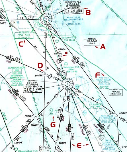
Take a look at the "*". Along that airway, you’ll see a black box that says "V3", meaning this is a segment of Victor 3. High altitude airways are called "Jet" routes. Though Jet routes are primarily found on high altitude enroute charts, they are also sometimes depicted on low altitude enroute charts. Take a look just to the left of "C" and you’ll see a green line. Follow it down just below the Vero Beach VOR identifier and you’ll see "J20-113". This indicates that this is a segment of both Jet 20 and Jet 113. Going back to "*", you’ll see that below the "V3", there is "2000". This is called your Minimum Enroute Altitude(MEA). This is the lowest you can fly to maintain obstruction clearance(1000ft in non-mountainous areas, 2000ft in mountainous) AND have adequate navaid reception. You’ll notice they’re all fairly low in Florida, but it’s not the same everywhere. Keep in mind that flying on a magnetic course of zero degrees to 179, you must fly odd thousand foot altitudes(ie 5000ft, 11000ft) and on a magnetic course of 180 to 359, you must fly even thousand foot altitudes(ie 8000ft, 14000ft). So, if you were heading southeast-bound on V3, even though the MEA is 2000ft, you’d have to fly at least 3000ft. Now take a quick look at "D". This triangle represents an "intersection". Just like roads we drive on, airways cross over each other and create intersections. This intersection is called "SMERE"(because it’s over the town of Fellsmere) and is defined by the intersection of V295 and the airway running north-south. Now, back to "*", you’ll see an intersection just above it called "VALKA". Above the V3, you’ll see "15". This indicates the DME distance from the Vero Beach VOR to VALKA intersection. We know this because just below the airway near VALKA, we see a "D" with an arrow pointing north. On the other side of VALKA, you see "12" which indicates the DME distance from VALKA to the Melbourne VOR. Now, right at the tip of the arrow, you’ll also see a six-sided shape with a "27" in it. This indicates the total distance between the two navaids that make up that segment of the airway(VRB and MLB). But more to the point as far as using the airway, if you look at where the airway starts at VRB, you’ll see that it’s defined by the 347 radial FROM VRB and on the other side, it’s defined by the 165 radial FROM MLB. Procedure says that you should switch from one to another half way in between unless otherwise specified. So, if you left VRB, you’d fly 357 FROM until about 15 miles DME away from VRB and then switch to flying 345 TO(the reciprocal of 165 FROM) MLB. Take a look on the south side of VRB and find V295 heading southeast. Below it’s box, you’ll see "2000", your MEA, but you’ll also see "1500T". This is your Minimum Obstruction Clearance Altitude(MOCA). This altitude assures you of your proper obstruction clearance, but only guarantees navaid reception within 22NM of the navaids. This is used in emergency situations where you’re not able to maintain the MEA(ie twin engine aircraft with an engine out). Since we’re down there, lets take a look at another thing. Just east of V295 near the edge of the image, you’ll see "ANGEE" intersection and if you follow the airway back to VRB, you’ll see that it’s 22DME from VRB. But, if we didn’t have DME, how would we know we were at ANGEE? Well, if you look at ANGEE, you’ll see a small line extending southwest that has "035" printed on it and a little further along it says "PHK 115.4". This indicates that if you set the NAV you’re not using to fly the airway to the PHK VOR and tune in the 035 radial, when it centers, you’ve reached ANGEE. Now, let’s move to "F". This is an airport identifier, in this case identifying my home, Vero Beach Municipal Airport. It’s ATIS freq. is at the top followed by the airport information. After it’s indentifier, you’ll see the MSL altitude and length of the longest runway in thousands of feet. Now, below that, in green, you’ll see the frequency and identifier of the Vero Beach NDB. Notice it doesn’t look the same as the Satellite NDB identifier we saw earlier. If you look back up at the Satellite NDB, you’ll see a green line extending out southeast off the edge of the chart. Though you can’t see it marked on the chart, this is BR1L, one of the Bahamas Routes. They are based on NDBs instead of VORs. So, if an NDB is used to make up a route, it will have a large identifier like the Satellite NDB does. Last, let’s take a look at "G". This large number is your Grid Minimum Off-Route Altitude(Grid MORA). As I said in the Overview, it is possible to fly direct from some places to another without having to use the airways. If you’re going to do this, you use your Grid MORA to determine the lowest altitude it is safe to fly at. In this case, in this grid on the chart, the lowest we could fly to maintain obstruction clearance would be 2700ft, but since we have set altitudes we must adhere to, we would have to be at least 3000ft eastbound and 4000ft westbound. Now, there’s even a way to cheat this, but it’s a technicality and complicated, so I’ll save it for later.
So that’s the basics of the enroute chart. Again, the main difference between low and high charts is the Victor airways vs. Jet routes. At higher altitudes, you can receive navaids further away(generally), so Jet routes can be made up of VORs that are further apart. That’s really the big difference. Now that we’ve got an idea of what the two main charts are telling us, let’s move on to actually doing some procedures...